 In comparing an old 1800's map of the Yellem Prairie and Google maps from today, you can see a few differences - especially the differences in the tree lines. The tree lines depicted in the old map below (1856 ) show two distinct tree lines outside of the area labeled Yellem Prairie both North and South. It is noted with the green color and curved lines. The Google map indicates only a remnant of that tree line left today. If you use a little imagination, you can see the top blue marker in the Google map, where a tree line is also noted in the 1856 map below. It may true that remnants of that tree line exist to this day.
  |
| http://www.blm.gov/or/landrecords/survey/yPlatView1_2.php?path=PWA&name=t170n020e_001.jpg |
 |
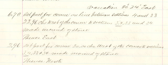
| Survey Notes 1858 Berry |
You may think that a mound of rocks is just an uninteresting heap of stone, but in the early times of Washington statehood and even prior to Thurston County's official naming, mounds of rocks were used to mark locations for travelers, linemen, axeman and surveyors.
Transcription from Survey Notes by Berry 1858.
"Variation 20* 24' East
6.70 Set post for corner on line between sections 4 and 33
22.96 chs (cks) West of the corner to sections 3.4.33 and 34
made mound of stone.
Thence East
2.96 Set post for corner 20.00 chs. (cks.) West of the corner to sections
3.4.33 and 24 made mound of stone
Thence North"
Survey notes of the Yellem Prairie 1856-58 also included information about oaks or large trees which were used to identify locations or map positions in the Yellem Prairie. When oaks or other large trees were not found nearby, a cedar post was installed with a mound of rocks. Installing the cedar post with a rock mound was required of the surveyor. There were no specific reasons given for the surveyor to do so, it was simply stated "installed as instructed."
Washington state recognizes a few properties on Railway Rd. in their Historical Property Survey. One or two such properties exist near the rock mounds. It is possible that these mounds of rock have been sitting there quietly, untouched for nearly 155 years. There are two such mounds that can be seen on Railway Rd. in Yelm. One just across from the other and are noted in the Google map along with the property from the state survey.
 |
| Location Approximations of Survey Posts with Stone Mounds |
The Yelm History Project discusses the many rock piles, mounds, and walls built by early settlers to the Yelm Prairie. Rock mounds provide cover for wildlife like snakes, frogs, raccoons, rabbits, skunks and insects. Read more about landscaping for wildlife from Washington State Department of Fish and Wildlife.


No comments:
Post a Comment